Sunscreen and Surf Warnings: Jacksonville’s Mid-Week Heat Surge
Morning: A Mild Start and Coastal Cautions
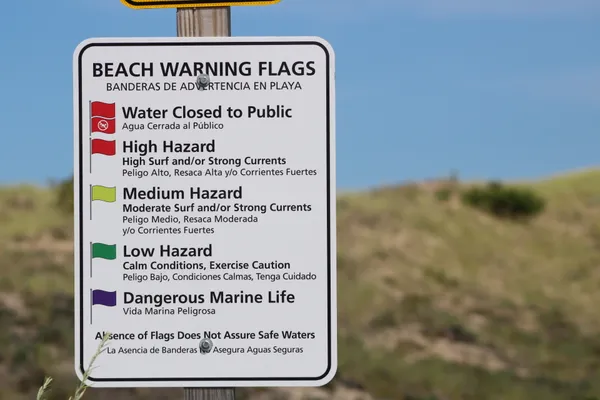
Jacksonville residents waking up this Wednesday morning, February 18, 2026, will find themselves in the midst of a significant warming trend that local meteorologists are calling a 'False Spring.' Early morning commuters along I-95 and I-10 can expect dry roads and clear visibility, with temperatures starting in a comfortable range between 55°F and 59°F. While the air feels pleasant, a High Rip Current Risk is in effect starting at 7:00 AM for all Northeast Florida beaches. The National Weather Service warns that even experienced swimmers should exercise extreme caution or stay near a lifeguard, as dangerous currents are expected to persist throughout the entire day.
Afternoon: Peak Warmth and Sunny Skies
As the day progresses, the 'spring tease' truly takes hold. By the afternoon, the mercury is expected to climb well above seasonal averages, reaching a high of approximately 79°F to 81°F. Skies will remain mostly sunny to partly cloudy, providing plenty of vitamin D for those taking an outdoor lunch break. A gentle southwest breeze will accompany the peak heat, though officials are keeping a close watch on the High Wildfire Risk currently affecting the region. Due to recent dry spells and low humidity, residents are advised to avoid any outdoor burning and to be mindful of activities that could spark a fire in dry brush areas.
Evening: A Gentle Cool Down Under Partly Cloudy Skies
The record-challenging warmth will begin to taper off as the sun sets, making for a beautiful evening for outdoor dining or a stroll through Riverside. Evening temperatures will gradually dip back into the 60s, eventually settling at an overnight low of 55°F. No rain is predicted for tonight, though cloud cover may increase slightly as we head into Thursday. This dry, warm pattern is expected to continue through the end of the week, with even higher temperatures potentially reaching the mid-80s by Friday.
Daily Weather Summary and Notifications
- Temperature Range: High of 81°F, Low of 55°F.
- Precipitation: 0% chance of rain; dry conditions expected through the night.
- Wind: Light southwest breeze throughout the afternoon.
- Weather Alerts: High Rip Current Risk (Active through Wednesday evening); Elevated Wildfire Risk due to dry conditions.
- UV Index: High; sunscreen is recommended for extended outdoor exposure.