Arctic Blast Grips the First Coast: Rare Snow Flurries and Record Cold Forecast
Arctic Blast Grips the First Coast: Rare Snow Flurries Possible Tonight
Jacksonville is bracing for one of the most significant weather events in years as a powerful Arctic cold front sweeps through the region. Today, Saturday, January 31, 2026, marks the beginning of a multi-day "Weather Impact Alert" that will bring record-breaking low temperatures and the rare possibility of snow flurries to the River City. Meteorologists describe this system as the strongest cold front to hit the First Coast in several years, originating from the Arctic Circle and enhanced by a major nor'easter developing off the Carolinas.
Morning and Midday: The Calm Before the Chill
The day started relatively mild compared to what is coming, but conditions are changing rapidly. By noon, temperatures are expected to hover around 50°F under mostly cloudy skies. However, do not let the moderate numbers fool you. Northwesterly winds at 10 to 20 mph are already beginning to pull frigid air into the area, making the "feels-like" temperature closer to 45°F. Residents are advised to finish any outdoor errands or property winterization early, as the mercury will begin a sharp, non-stop descent starting in the early afternoon.
Afternoon: Plunging Temperatures and Rising Winds
As we move into the afternoon hours, the cold front will make its presence felt with authority. Temperatures will fall steadily through the 40s. A Wind Advisory is currently in effect, with sustained northwesterly winds increasing to 20-30 mph. High-profile vehicles and those with loose outdoor items should take immediate caution, as gusts are forecast to reach between 40 and 50 mph. These winds will cause wind chills to drop significantly, reaching the upper 20s by the time the sun sets.
Evening and Overnight: A Rare Winter Wonder?
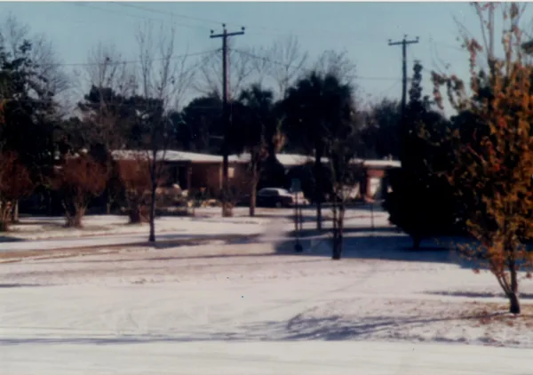
The most dramatic transition occurs this evening. Forecasters have issued an Extreme Cold Warning as temperatures are expected to plummet into the 30s by 6 p.m. and reach a low of 28°F by midnight. Most notably, moisture lingering behind the front could lead to isolated snow flurries for coastal Duval and Nassau counties on Saturday evening. While no accumulation is expected, the sight of white flakes in Northeast Florida is a testament to the historic nature of this air mass. By Sunday morning, wind chills are projected to fall into the single digits, potentially reaching as low as 8°F.
Safety Warnings and Critical Precautions
With life-threatening cold on the horizon, the National Weather Service and local officials have issued several critical notices:
- Extreme Cold Warning: In effect through Sunday morning. Residents must protect the "Four Ps": People, Pets, Plants, and Pipes.
- Wind Advisory: High winds today and tonight may cause minor property damage or isolated power outages.
- Hard Freeze Warning: Ensure that outdoor pipes are wrapped and irrigation systems are turned off to prevent bursting as temperatures drop well below freezing overnight.
Stay tuned to jacksonville.news for live updates as this historic cold front continues to move through the region.