Arctic Blast Grips Jacksonville: Freeze Warnings and Wind Chill Advisories in Effect
A Frigid Tuesday Morning for the First Coast
Jacksonville residents are waking up to a dramatic shift in weather this Tuesday, February 24, 2026. After a period of record-breaking warmth that saw temperatures climb into the high 80s over the weekend, a powerful cold front has swept through the region, plunging the city into an arctic chill. The National Weather Service has issued a Freeze Warning for the entire area, remaining in effect until 9:00 a.m. this morning.
For those heading out early, the conditions are particularly harsh. Inland areas west of I-95 are experiencing a hard freeze, with morning lows dipping into the mid-to-upper 20s. Even along the coastal beaches, temperatures have struggled to stay above the freezing mark, hovering in the low 30s. A Cold Weather Advisory is also active until 9:00 a.m. due to a light northwesterly breeze that is driving wind chill values down into the low 20s. Residents are urged to bundle up in layers and limit skin exposure during the early commute.
Sunny Skies but Chilly Afternoon Conditions
Despite the biting cold at daybreak, the afternoon promises plenty of sunshine. The sky is expected to remain mostly clear throughout the day, though the sun will do little to significantly warm the air. Forecasted highs for this afternoon are struggling to reach the 60-degree mark, with most of Jacksonville settling in the mid-to-upper 50s. The brisk northwest winds of 10 to 15 mph observed this morning will begin to taper off after noon, settling into a lighter 5 to 10 mph breeze by sunset.
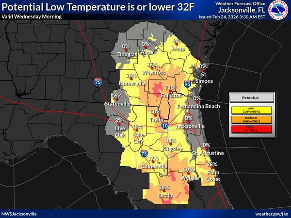
Evening Outlook and Overnight Frost Prep
As the sun sets at 6:21 p.m., temperatures will once again drop rapidly. Tonight is expected to be clear and calm, which creates the perfect conditions for radiant cooling. Forecasters are already predicting another round of frost and light freeze conditions for early Wednesday morning. Because the air remains very dry, there is a 0% chance of rain, but the lack of cloud cover means the heat will escape quickly into the atmosphere.
Community Safety and Alerts
In response to the extreme temperature swing, the City of Jacksonville has activated its Warming Center Contingency Plan. The Legends Center on Soutel Drive remains open this morning to assist vulnerable residents, with JTA providing transportation for those in need. Local experts recommend the following precautions for the next 24 hours:
- Protect the Four P's: Ensure pets are brought indoors, cover sensitive plants, insulate exposed pipes, and check on elderly neighbors.
- Space Heater Safety: If using a space heater, keep it at least three feet away from flammable materials and never leave it unattended.
- Hydration for Plants: Watering plants before a freeze can actually help protect their root systems by insulating the soil.
Stay tuned to jacksonville.news for further updates as we monitor this late-winter cold snap.